Tutkimushanke Pyhäjärven Kotolahden alustava vedenalainen tutkimus
Takaisin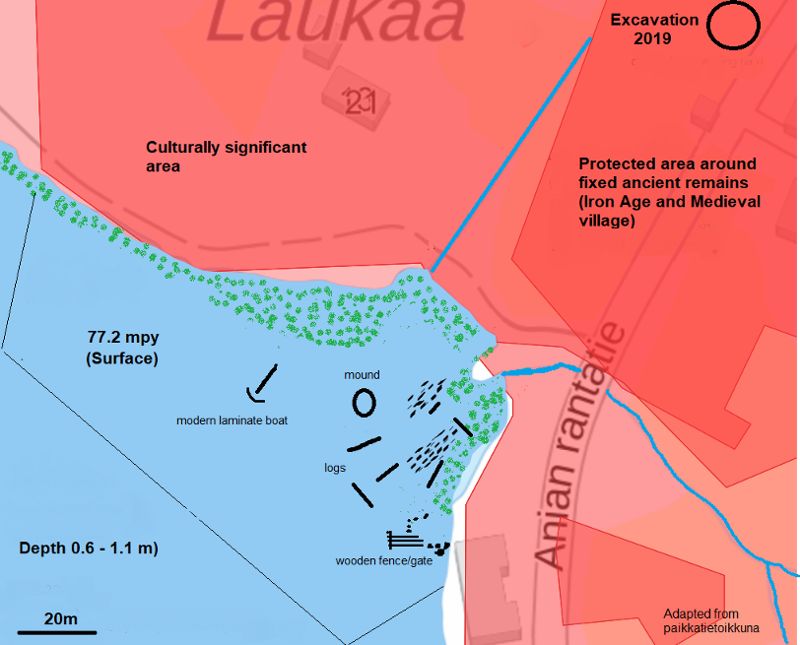
Perustiedot
-
Kunta:Pirkkala
Nimi:Pyhäjärven Kotolahden alustava vedenalainen tutkimusHankkeen tyyppi:Arkeologinen inventointi
Hankkeen lyhyt kuvaus:Preliminary land and underwater survey of the shoreline and waters adjacent to the Iron age site of TursiannotkoVastuutaho/vastuuhenkilö:PMM/ David CleasbyHankkeen alkupvm:04.06.2019Hankkeen loppupvm:13.08.2020
Tekstitiedot
-
Johdanto:The main aim was to find evidence of Iron Age or later period use of the lake. The site of Tursiannotko has been investigated many times over the last 50 years, but there is little data connecting the site to use of the lake, whether in terms of transport, trade or fishing its resources. A secondary aim was to practice survey techniques in shallow lake land conditions, and assess the methodological benefits and problems involved.
One day of investigation was undertaken in 2019 by snorkelling, the second in 2020 by diving the site
On post analysis the lake levels through the past were investigated and a reimagined map of the iron age site reconstructed. Some diagrams are added at the end. A research article has been added to give more detail.
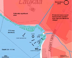
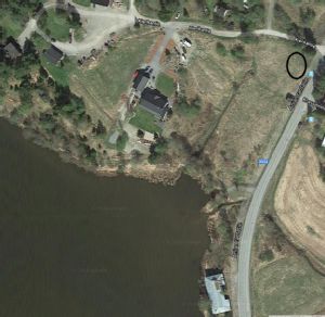
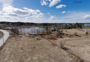
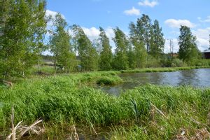
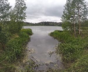
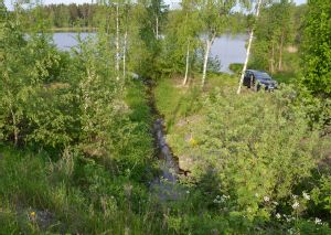
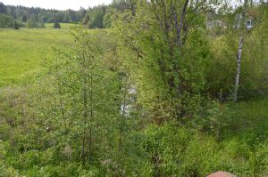
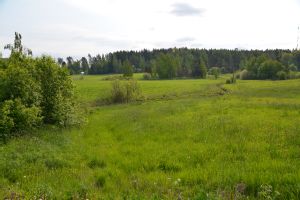
Hankealue:The site chosen was the lake land shore and waters of Kotolahti bay, directly adjacent to the Tursiannotko excavation site.An area of lake 150-200m wide along the shore was chosen, extending from a line of sight from the edge of a building by the shore on the south side, to a point on the north-west side that was level with the second set of buildings to the west of Tursiannotko. This surveyed area extended 50 m - 70 m out across the bay. This area was not strictly demarcated, as the objective was not to survey the whole lake, but simply elements closer to the current shore, with highest possibility of finding archaeological structures as well as evidence of water transport. In effect, the area surveyed comprised the area of water between 2 local promontories on the north shore. This encompassed the 3 channels that stretch inland, all possible water access points to it and from it, as well as all land areas that were adjudged to have simple downhill access to the water from the known Tursiannotko site. Survey paths taken on the water were not tracked by GPS coordinates as no waterproof equipment was available.
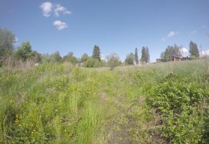
This survey also included visual and tactile investigation of 3 waterways extending inland from the bay, as it was theorized that there might be areas of previous water-related activity of interest now under modern soil levels. 'Channel 1', to the west of the Tursiannotko site (see Project map), extended some 100 meters roughly north inland, rising up and tapering off with the higher contours nearer the top of the hill. Its lower end has been blocked off by a dirt track road, so it no longer reaches the lake, rising from the lake shore from around 78 metres above sea level almost to 80 metres. The lower segment of the inland stretch is full of stagnant water, added to by rainwater and run off from higher ground, some 6 -10 ft wide at its base, depth around 30 cm at most, and which dries out further up the hill. It has clearly been exposed to the lake in the past as soil colour in the whole area nearer the lake is darker, seen by eye as well as aerial photographs. This channel has been isolated from the lake by a modern dirt track, which is shown on the Land survey underlay.
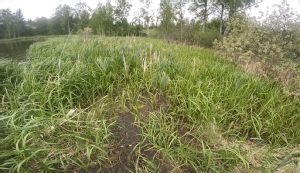
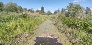
'Channel 2' was a small inlet, possibly of ancient origin, possibly modern, that was used for diver and snorkelling access in this project. It was short, around 20m long and around 3-4 meters in width, and located close to the dirt track access. This area was included as it may well have been part of the ancient watercourse route flowing out into the lake from inland.
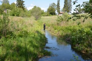
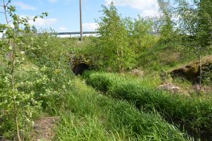
'Channel 3' extended from the lake inland under a bridge which carried the Anian Rantatie road north-south, and was clearly part of the course of the stream that existed, and snakes inland for over 5 km towards the airport.
Photographs were also taken of the areas to the East of the Anian Rantatie to get a full sense of the modern landscape and the geological processes that may have been at play.
In post analysis the lake levels for the Iron Age were reconstructed which indicated future research should move to an internal lagoon to the east of the site and the channel to the west of the Iron Age village.
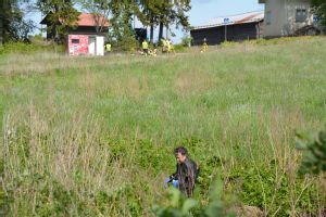
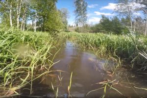
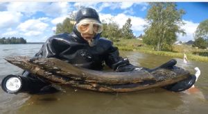
Aikaisemmat hankkeet:Many investigations have occurred at Tursiannotko over some 50 years from archaeological (Raninen 2019), historical and etymological perspectives (Heikkilä 2017). However, there are no published accounts of investigations taken on the foreshore or of the lake. Mention has been made that the Suomen Meriarkeologinen Seura Ry conducted dives in the lake area in the past, but no data has been officially published. An aerial photographic survey by drone of the known and expected Iron Age occupation sites was taken by Wesa Perttola, but was confined mainly to the occupation sites and did not extend to the shoreline or the lake (Pers. Comm 2020). No geological studies have occurred that specifically concern this area, simply regional level data on Maankamara, showing the lowest level geological layers. There have been various studies of water level changes in Pyhäjärvi, giving rough estimates of how its levels have changed over time. A previous survey by Adel (2017) found a modern painted boat on the other side of the bay, showing that even in modern times with its lower water level that boats with a shallow draught could function on the lake, and were even more likely to do so in ancient times when water levels were higher.Menetelmät:2019 Snorkelling surveyInwater - Protective, waterproof and warm clothing was employed, for which scuba drysuits were the best solution, since there were risks factors not only from exposure but also contamination from stagnant water and possible Weil's disease. Survey while in the water was always done as a pair, according to standard scuba-diving practices and safe working practices, despite the fact that only snorkelling being conducted in the end. Due to the shallow nature of the water areas to the south and the acceptance that many areas could not be accessed due to the reed bushes, the first survey was conducted by snorkelling, as it was felt this would be easier and quicker than employing diving techniques. Both myself and the other diver, Ari Pajunen (a member of the Suomen Meriarkeologinen Seura Ry, a Scientific diver, and a part-time boat builder), swam across the area, some 2-3 metres apart in a line, perpendicular to the shore, trying to identify features on the lake bottom, and discussing what was found.
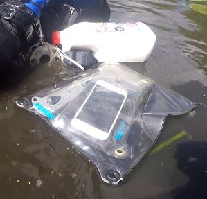
Any items found were raised temporarily so they could be recorded and discussed, as visibility was poor, and then laid back down. No finds were raised that seemed attached to other structures. GPS coordinates were not taken as waterproof equipment was not available, but simple visual transits were taken and recorded on video with a GoPro 4.
The same technique was employed on the north and west survey snorkelling survey lines selected. Several transits of the area were taken, with divers some 2-5 m apart.
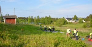
Onshore- simple inspection with hands was undertaken to check if there were features or items of cultural value. Each channel was walked over several times and photographs taken, as well as videos with verbal observations. this was appropriate since this was simply a preliminary survey to assess the area's cultural potential.
2020 Diving survey
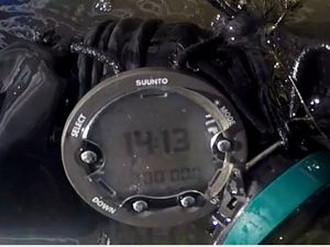
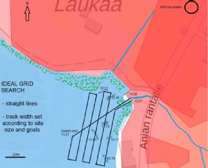
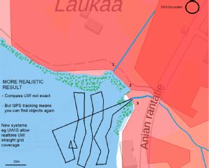
Diving was undertaken in the middle of August with Sanna Siltanen from Suomen Meriarkeologinen Seura. The same area as previous survey was covered. Bottom coverage was worse than in 2019 due to thick fronds of lillies. The methodology was slightly changed and improved. A GPS in a dry bag was floated on the surface, synchronised to a dive watch, so that an attempt was made to cover the lake bottom in straight systematic tracks. However, poor visibility due to the lillies made this very difficult.
Tulokset:2019 Snorkelling resultsThere were no cultural items or features identified in any of the channels, but a sense of the environmental processes involved was gained. Channel 1 to the west of the excavated area had clearly been partially destroyed by the building of a dirt road near the shoreline. There had clearly been some infiltration of water in the past, which extended quite some way up the hill, as evidenced by the similarities in soil type on the edges of the waterfilled section, and the dried up areas further up the hill, which was an interpretation implied in the aerial drone photograph. The tapering of the small ditch valley in which the present water lies, allied with the shape of the contours would seem to echo the interpretation that water extended much further up the slope at some time than is seen now. Later literature research confirmed that the water may have risen up to 79 or 80 metres above sea level between the Mesolitihic into Iron Ages (Adel 2005).
It is unknown what were the creation processes of the smaller channel 2. It is short and narrow. No finds or features were discovered there. Visibility here was extremely poor due to the vegetation and general sludge. It could have been made as a modern access point for boats to the lake, or created when Channel 3 was lined with gravel. It could also be part of the ancient Channel to the lake of the Kokemäenjoki river, as it passed through the locally named 'Juoksianoja' drainage channel.
Channel 3 seems to have been gravel lined to avoid siltage. It comprises a stream, some 2m wide at maximum, and shallower than channel 3. It follows the same dimensions up to a modern bridge and follows through to the lower areas on the east side of the road. No cultural items were found in the channel, and which seems logical, due to the potential damage caused when re-modelling of the watercourse occurred at some point in the last 100 years. It seemed possible from the close proximity, low lying nature of the ground and soil type between channels 2 & 3 that they may well have part of the same water course in the past.
Regarding the snorkelling surveys several finds were discovered, which are likely to be relatively modern in age, and certainly not Iron Age. See attached adapted map and video.
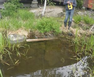
Finds 'a' to the east comprised of several flat stones (around 30 cm x 30cm) that seemed to form some sort of semi-circular perimeter, near the building. Similar stones were present near the waters edge, immediately adjacent to the building. It seems likely that they are present through some relationship to the building, perhaps as an area of laid solid ground to launch a boat, go swimming etc, with the stone perimeter forming an effective barrier to the siltage and vegetation growth that occurs close to it.
The planks at 'b' seemed of indeterminate age. The planks fitted side by side, with a thick cross piece of iron piece with bolts attaching them that resembled a hinge. They did not resemble known boat features or local modern traditions, which seem to have a clinker style tradition, as per the boat found by Adel (2017). The hinge seems to imply a gate of some point. Perhaps coincidentally the building walls lack many of their lower planks.
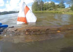
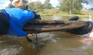
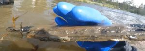
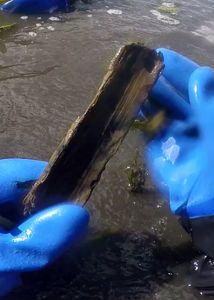
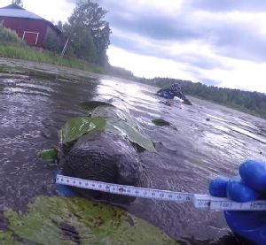
The planks at 'c' are clearly from a boat. One large piece, 2-3 m long, comprised 2 attached planks that overlap. They have short rusted iron at regular intervals, more like rivets , then iron nails. There was also some thin strips on metal, possibly lead or aluminium along the top edge of the planks. It was impossible to ascertain the age from its style. A smaller piece was found that had glue or some sort of sealant attached to it. It also had what looked like several compressed layers, held together with the glue, which boat builder Ari Pajunen felt was evidence of a laminate technique for boat building, a technique that is apparently no older than 120 years. A sizeable piece of timber seemed to have come from a keel or cross timbers, and showed several layers, joined by glue and not by any scarf joints. There was also evidence that small metal strips were attached.
There was also a raised area found on the lake bottom roughly between channels 1 & 2, some 50 cm raised off the bottom of the lake floor. It was not possible to see what the object was as it was covered in silt and the visibility was poor.
2020 Diving results
Several intake logs discovered, most had been trimmed. These had probably floated in here from elsewhere. Large amounts of rocks were identified around the outlet of channel 3, the stream outlet , probably there to prevent silting and some carried down by the stream when it was more of a river.
Yhteenveto:No evidence was found of any obvious Iron age or medieval features. The boat pieces seem by morphology and by building technique to be relatively modern, and do not at this stage warrant further dating investigations by dendrochronology or carbon dating. However, further visits will be scheduled to the area to examine and record these items again but this time insitu, as well as to widen the search underwater. This will include the curious raised area and laid stones. A underwater metal detector survey may also be employed.However, the survey has merit because it gave some insight into the advantages and disadvantages of a survey in such conditions. On the positive side, such preliminary surveys can be carried out quickly with simple snorkeling techniques. On the initial negative side a different approach needs to be taken, but one that should yield better results. The finds need to be measured and photographed insitu without disturbing the bottom and destroying the visibility, and not by lifting the objects from their context. The finds' locations need to be fixed with GPS, so they can be found more readily. The local ecology also poses interesting problems and positive learning, in particular the dense vegetation which does not allow survey of the areas closest to the actual shoreline, places where archaeological structures, boats and past activities may be deposited. It is unclear how one would examine the underwater areas closest to the modern shoreline without employing dredgers or large equipment. Even if this could be managed logistically and heavy equipment found that can operate in shallow water, the damage to the potential cultural finds would be great. On the 2020 dives the thick lilly fronds made the survey impossible. Therefore, methodology must include an understanding of local conditions.
Studying the land topography provided ideas as to how the foreshore may have looked in the past. It seems likely that water from the lake was present higher up the western channel, and not perhaps too far from the Iron Age village. If the water level was higher there then it is likely that the area between channels 2 & 3 was underwater in the past. If so then the area that was being surveyed was very unlikely to yield any Iron Age remains. Future areas to yield results would be to expand diving surveys to the whole bay, or to excavate on land closer to where the water level may have reached in Iron Age times.
Post analysis has indicated that the water level was 3metres or more higher in the Iron Age. The channel to the west of the site would have been higher, and a large internal lagoon to the east of the site, where water would have flowed in from the lake via the stream outlet, which was likely to be wider in the Iron Age as the stream was more a river then. The western channel and eastern lagoon may well have allowed boats to be beached close to the village, and future investigations could be targetted there. See the attached article, written for publication, which follows this theory.
Lähteet:Adel, V 2005: Historiallisen ajan muinaisjäännösten inventointi Lempäälän kuokkalankoskella. - Pirkan maan alta 6. Arkeologisia tutkimuksia. Tampereen museot. S. 74-5.Adel, V 2017. Tursiannotkon-Pirkkalankylän muinäisjäännösalueen tutkimushistoriaa. - Pirkan maan alta 15. Arkeologisia tutkimuksia. Tampereen museot. S. Takasivun valokuva.
Heikkilä, M 2017. Birkan koivot vai saksan karhu hiiden ja vesihiiden naapurina Pirkkalankylässä? Tutkimus Pirkkalan vanhimmasta tunnetusta paikannimistöstä. - Pirkan maan alta 15. Arkeologisia tutkimuksia. Tampereen museot. S 32.
Raninen, S 2019. In the Hollow of Tursas? - An Overview of an Archaeological Work-in-Progress. In, Ahola, J & Wilson, K (eds) Interdiscoplinary and Comparative Methodologies no.14, Exploring Circum-Baltic Cultures and Beyond. The Retrospective Methods Network RMN Newsletter. Folklore Studies/ Department of Cultures, University of Helsinki, Helsinki.
https://kartta.paikkatietoikkuna.fi/
Löydöt:None recovered.
Media
-
18. Finds & Reed beds.png
- Kuvaaja:
-
Kuvatyyppi:
-
Kuvaus: - Light red areas are the Archaeological protected area, with deep red other areas of cultural value.
- Dark black Circle shows 2019 Excavation area
- Green dots in water show rough extent thick reeds and foliage. Unable to penetrate.
1. Ancient water channel to the west of excavated area
2. Channel used for diver access, near to road access. ? age created or natural. Possible part of the original water course, along with Channel 3.
3. Site of present water course, gravelled, extends through tunnel under road.
a semi large laid stones, apparently in a rough Perimeter near building ...? associated.
b. planks about 2m long, 30cm wide, unknown age, connected by a cross-strut. Planks not overlapping. Iron metal clamp seems to resemble a gate? Possible part of modern building structure
c. 3 pieces of wood - 2 long planks about 3m long, 20cm wide, with iron bolts Secured through. Planks overlapping. Boat? age
- smaller thin piece ... 1m x 5cm ... contained modern glue or Silicone sealant on one edge
- Thick piece of boat structure, signs of lamination technique used, and Glueing. Probably relatively modern, maximum age.100-120 years.
d. Solid raised area under the label. 1m x 1m, elevation 50cm. Unable to ascertain identity due to label cover and visibility.
e) Rough extent of area surveyed by snorkelling.
-
Kuvausaika:
Linkitetty KuvaSiiri-kuva
- Diaarinumero: KYY 369
- Alanumero: 1
-
Kuvaus:
- Kuvaaja: Maanmittauslaittos
- Kuvausaika: 04.06.2019
Linkitetty KuvaSiiri-kuva
- Diaarinumero: KYY 369
- Alanumero: 2
-
Kuvaus:
- Kuvaaja: Cleasby
- Kuvausaika: 04.06.2019
Linkitetty KuvaSiiri-kuva
- Diaarinumero: KYY 369
- Alanumero: 3
-
Kuvaus:
- Kuvaaja: Wesa Perttola
- Kuvausaika:
Linkitetty KuvaSiiri-kuva
- Diaarinumero: KYY 369
- Alanumero: 4
-
Kuvaus:
- Kuvaaja: David Cleasby
- Kuvausaika: 04.06.2019
Linkitetty KuvaSiiri-kuva
- Diaarinumero: KYY 369
- Alanumero: 5
-
Kuvaus:
- Kuvaaja: David Cleasby
- Kuvausaika: 04.06.2019
Linkitetty KuvaSiiri-kuva
- Diaarinumero: KYY 369
- Alanumero: 6
-
Kuvaus:
- Kuvaaja: David Cleasby
- Kuvausaika: 04.06.2019
Linkitetty KuvaSiiri-kuva
- Diaarinumero: KYY 369
- Alanumero: 7
-
Kuvaus:
- Kuvaaja: David Cleasby
- Kuvausaika: 04.06.2019
Linkitetty KuvaSiiri-kuva
- Diaarinumero: KYY 369
- Alanumero: 8
-
Kuvaus:
- Kuvaaja: David Cleasby
- Kuvausaika: 04.06.2019
Linkitetty KuvaSiiri-kuva
- Diaarinumero: KYY 369
- Alanumero: 9
-
Kuvaus:
- Kuvaaja: David Cleasby
- Kuvausaika: 04.06.2019
Linkitetty KuvaSiiri-kuva
- Diaarinumero: KYY 369
- Alanumero: 10
-
Kuvaus:
- Kuvaaja: David Cleasby
- Kuvausaika: 04.06.2019
Linkitetty KuvaSiiri-kuva
- Diaarinumero: KYY 369
- Alanumero: 11
-
Kuvaus:
- Kuvaaja: David Cleasby
- Kuvausaika: 04.06.2019
Linkitetty KuvaSiiri-kuva
- Diaarinumero: KYY 369
- Alanumero: 12
-
Kuvaus:
- Kuvaaja: David Cleasby
- Kuvausaika: 04.06.2019
Linkitetty KuvaSiiri-kuva
- Diaarinumero: KYY 369
- Alanumero: 13
-
Kuvaus:
- Kuvaaja: David Cleasby
- Kuvausaika: 04.06.2019
Linkitetty KuvaSiiri-kuva
- Diaarinumero: KYY 369
- Alanumero: 14
-
Kuvaus:
- Kuvaaja: David Cleasby
- Kuvausaika: 04.06.2019
Linkitetty KuvaSiiri-kuva
- Diaarinumero: KYY 369
- Alanumero: 15
-
Kuvaus:
- Kuvaaja: David Cleasby
- Kuvausaika: 04.06.2019
Linkitetty KuvaSiiri-kuva
- Diaarinumero: KYY 369
- Alanumero: 16
-
Kuvaus:
- Kuvaaja: David Cleasby
- Kuvausaika: 04.06.2019
Linkitetty KuvaSiiri-kuva
- Diaarinumero: KYY 369
- Alanumero: 17
-
Kuvaus:
- Kuvaaja: David Cleasby
- Kuvausaika: 04.06.2019
Linkitetty KuvaSiiri-kuva
- Diaarinumero: KYY 369
- Alanumero: 18
-
Kuvaus:
- Kuvaaja: David Cleasby
- Kuvausaika: 04.06.2019
Linkitetty KuvaSiiri-kuva
- Diaarinumero: KYY 369
- Alanumero: 19
-
Kuvaus:
- Kuvaaja: David Cleasby
- Kuvausaika: 04.06.2019
Linkitetty KuvaSiiri-kuva
- Diaarinumero: KYY 369
- Alanumero: 20
-
Kuvaus:
- Kuvaaja: David Cleasby
- Kuvausaika: 04.06.2019
Linkitetty KuvaSiiri-kuva
- Diaarinumero: KYY 369
- Alanumero: 21
-
Kuvaus:
- Kuvaaja: David Cleasby
- Kuvausaika: 04.06.2019
Linkitetty KuvaSiiri-kuva
- Diaarinumero: KYY 369
- Alanumero: 22
-
Kuvaus:
- Kuvaaja: David Cleasby
- Kuvausaika: 04.06.2019
Linkitetty KuvaSiiri-kuva
- Diaarinumero: KYY 369
- Alanumero: 23
-
Kuvaus:
- Kuvaaja: David Cleasby
- Kuvausaika: 04.06.2019
Linkitetty KuvaSiiri-kuva
- Diaarinumero: KYY 369
- Alanumero: 24
-
Kuvaus:
- Kuvaaja: David Cleasby
- Kuvausaika: 04.06.2019
Linkitetty KuvaSiiri-kuva
- Diaarinumero: KYY 369
- Alanumero: 25
-
Kuvaus:
- Kuvaaja: David Cleasby
- Kuvausaika: 04.06.2019
Linkitetty KuvaSiiri-kuva
- Diaarinumero: KYY 369
- Alanumero: 26
-
Kuvaus:
- Kuvaaja: David Cleasby
- Kuvausaika: 04.06.2019
Linkitetty KuvaSiiri-kuva
- Diaarinumero: KYY 369
- Alanumero: 28
-
Kuvaus:
- Kuvaaja: David Cleasby
- Kuvausaika: 13.08.2020
Linkitetty KuvaSiiri-kuva
- Diaarinumero: KYY 369
- Alanumero: 29
-
Kuvaus:
- Kuvaaja: David Cleasby
- Kuvausaika: 13.08.2020
Linkitetty KuvaSiiri-kuva
- Diaarinumero: KYY 369
- Alanumero: 30
-
Kuvaus:
- Kuvaaja: David Cleasby
- Kuvausaika: 13.08.2020
Linkitetty KuvaSiiri-kuva
- Diaarinumero: KYY 369
- Alanumero: 31
-
Kuvaus:
- Kuvaaja: David Cleasby
- Kuvausaika: 13.08.2020
Linkitetty KuvaSiiri-kuva
- Diaarinumero: KYY 369
- Alanumero: 32
-
Kuvaus:
- Kuvaaja: David Cleasby
- Kuvausaika: 11.03.2021

Linkitetty KuvaSiiri-kuva
- Diaarinumero: KYY 369
- Alanumero: 33
-
Kuvaus:
- Kuvaaja: David Cleasby
- Kuvausaika: 11.03.2021
Arkeologiset kohteet
-
Tunnuskuva Kunta Vanha kunta Nimi Kylä Kaupunginosa Muinaisjäännöstunnus Muinaisjäännöstyyppi Laji Ajoitus 
AvaaPirkkala
Tursiannotko Pirkkala
604010015 asuinpaikat
kiinteä muinaisjäännös historiallinen
kivikautinen
moniperiodinen
rautakautinen